
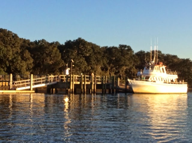
Another short passage, though made longer because Lene had to go grocery shopping again, her fourth day in a row! So we did not leave until early afternoon, when the tide was flooding into the St. Marys River, reducing our speed. Once we arrived and the anchor was securely set, some course plotting for the stops between here and Fort Lauderdale, a good dinner and we snuggled in for a night that was supposed to be even colder than the one before, but wasnt. While I played with the charts, Lene checked out Cumberland Island by trhe internet. It is a "National Seashore" administered by the National Parks Service. Im grateful to Dick and Elle for suggesting Cumberland as a great place to stop and to Lene who found the activities on the island. It is very roughly the size of Manhattan Island and we passed its beachy Atlantic coastal side while heading south for the St. Marys River inlet about a week ago. Our anchoring location was on its east coast, just off "Sea Camp", the NPS ferry dock,
where small boatloads of passengers come over from St. Marys, twice a day, to mingle with folks like us who come on our own bottoms.
 All the tourists are also divided among those, like us, who spend a day (or less) on the island and those who bring tents, food, water etc., and camp out at its camp sites, by permit, for up to a week, $4.00 per head! The campers can be further divided between those who take campsites less than a mile from the dock, and those who carry all their stuff up to eleven miles (and back) to camp at wilderness sites.The eight folks here came as a group, took the near option and very friendly.
 We were fortunate to get two open spots (another couple had not been able to make it) on a guided tour for eight people in a government van for only $12 per senior.

led by NPS agent Roy

This was a six hour tour and Roy kept talking to us throughout and answering our questions about the geology, flora, fauna, history and politics of the island and the state of Georgia. He was a great tour guide and very knowledgeable...and isnt allowed to accept gratuities!
We saw an armadillo

and more than a dozen of the 150 wild horses who inhabit this island.
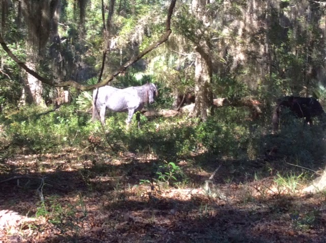 They receive no food or veterinary services but live breed and die on the island and are quite unafraid of humans. They are smaller than the jumpers and hunters I know from barns and their life expectancy is half that of domesticated horses. They and the wild boar, were introduced here by the Spanish. We also saw wild turkeys and deer, close up, but without photos.
Live oaks predominate. This one extends further to the right than shown, and as you can see, is quite wider than it is tall. They
 are not harmed by the Spanish Moss that hangs from them, except to the extent that when wet, and the moss can hold up to ren times its weight in water, can break branches off the trees.. The branches can curve down to the ground and back up again, when they grow in open cleared fields, like the one pictured. Most of them are "Second Growth"; the primeval forest having been cut down to supply curved timbers for building ships like Old Ironsides, the USS Constitution, made largely of Cumberland Island live oak.
We visited the first African Baptist Church, near the north end, a very small, one room chapel in which John John F. Kennedy Jr. was married. It was also visited by President Carter, a Georgia boy.

We stopped at Plum Orchard, a huge formal house, of about 25,000 square feet, built by the widow of Andrew Carnegies brother, for one of their sons and his wife. Completed with indoor squash court and swimming pool about 112 years ago, it reminded me a bit of Downton Abbey, in terms of the social structure and activity norms of the people who lived there.

Even larger, 37,000 square feet, was the Dungeness Mansion, built by Mrs. Carnegie for herself on the ruins of the home of the former plantation owner. Her kids decided not to maintain it after her death so only the stone and bare verticals remain.
 Ms. Carnegie owned about 95 percent of the island. Sadly, those kids, who never had to go to school or do any work, generally died young, of alcohol related disorders. Roy told us there were very limited fond feelings among the children for their mother.
The island is now almost entirely owned by the government but about five percent of it is held by about 25 folks with "reservations of rights", i.e., the right to exclusive control of their land until they die. Then, one by one, the government will take over and will either restore the buildings for park or administrative uses if they have historic value or raze the structures and let the wilderness take over again. One such rights holder is Carol, who like the horses, lives off the land, at the north end, and has done so for 44 years, while becoming an expert on sea turtles.
This wall is made of "tabby" which is home made "cinder blocks" molded from burned seashells, sand and water to make a cement in which unburned sea shells are embedded in lieu of gravel to make concrete.

In the morning I went back for a walk across the island to the sea. Even with light waves, you could hear the Atlantics roar from half mile away. Long board walks to avoid disturbing the very wide dunes;
 except the horses tracks show that they ignore the signs.
And then there is a very wide beach. You can barely see the three NC elementary school teachers, seated, half way back to the dunes, just slightly to the right of center.

On our way back north, we hope to explore this island by bike. We loved Cumberland.
Read More..
 |
| Dinghy left, ILENE, right |
where small boatloads of passengers come over from St. Marys, twice a day, to mingle with folks like us who come on our own bottoms.
led by NPS agent Roy
This was a six hour tour and Roy kept talking to us throughout and answering our questions about the geology, flora, fauna, history and politics of the island and the state of Georgia. He was a great tour guide and very knowledgeable...and isnt allowed to accept gratuities!
We saw an armadillo
and more than a dozen of the 150 wild horses who inhabit this island.
Live oaks predominate. This one extends further to the right than shown, and as you can see, is quite wider than it is tall. They
We visited the first African Baptist Church, near the north end, a very small, one room chapel in which John John F. Kennedy Jr. was married. It was also visited by President Carter, a Georgia boy.
We stopped at Plum Orchard, a huge formal house, of about 25,000 square feet, built by the widow of Andrew Carnegies brother, for one of their sons and his wife. Completed with indoor squash court and swimming pool about 112 years ago, it reminded me a bit of Downton Abbey, in terms of the social structure and activity norms of the people who lived there.
Even larger, 37,000 square feet, was the Dungeness Mansion, built by Mrs. Carnegie for herself on the ruins of the home of the former plantation owner. Her kids decided not to maintain it after her death so only the stone and bare verticals remain.
The island is now almost entirely owned by the government but about five percent of it is held by about 25 folks with "reservations of rights", i.e., the right to exclusive control of their land until they die. Then, one by one, the government will take over and will either restore the buildings for park or administrative uses if they have historic value or raze the structures and let the wilderness take over again. One such rights holder is Carol, who like the horses, lives off the land, at the north end, and has done so for 44 years, while becoming an expert on sea turtles.
This wall is made of "tabby" which is home made "cinder blocks" molded from burned seashells, sand and water to make a cement in which unburned sea shells are embedded in lieu of gravel to make concrete.
In the morning I went back for a walk across the island to the sea. Even with light waves, you could hear the Atlantics roar from half mile away. Long board walks to avoid disturbing the very wide dunes;
And then there is a very wide beach. You can barely see the three NC elementary school teachers, seated, half way back to the dunes, just slightly to the right of center.
On our way back north, we hope to explore this island by bike. We loved Cumberland.


